Planning a holiday in Turkey and wondering how far it is from Antalya Airport to Alanya,
where fairy-tale Cappadocia is tucked away, or which side of the country boasts the Aegean
Coast? Our interactive map with category filters helps you plan itineraries, calculate
driving times, and discover holiday destinations effortlessly.
Interactive Map of Turkey: Cities, Resorts & Sights
Use the filter buttons below to sort map pins by category: holiday beach resorts, major
metropolises, international airports, or renowned UNESCO heritage sites.
Loading Turkey Map...
Click to enable map interaction
Beach Resorts Major Cities Airports UNESCO & Natural
Sights
REKLAMA
Tourism Geography
Key Holiday Regions Across Turkey
Sunny South
The Turkish Riviera (Mediterranean Coast)
Stretching along the Gulf of Antalya, this is Turkey's premier beach corridor: lively
Alanya with its Seljuk clifftop castle, historic Side
set right on an ancient peninsula, golfing haven Belek, and
pine-fringed Kemer backdropped by the towering Taurus Mountains.
Swimming season runs from May through November.
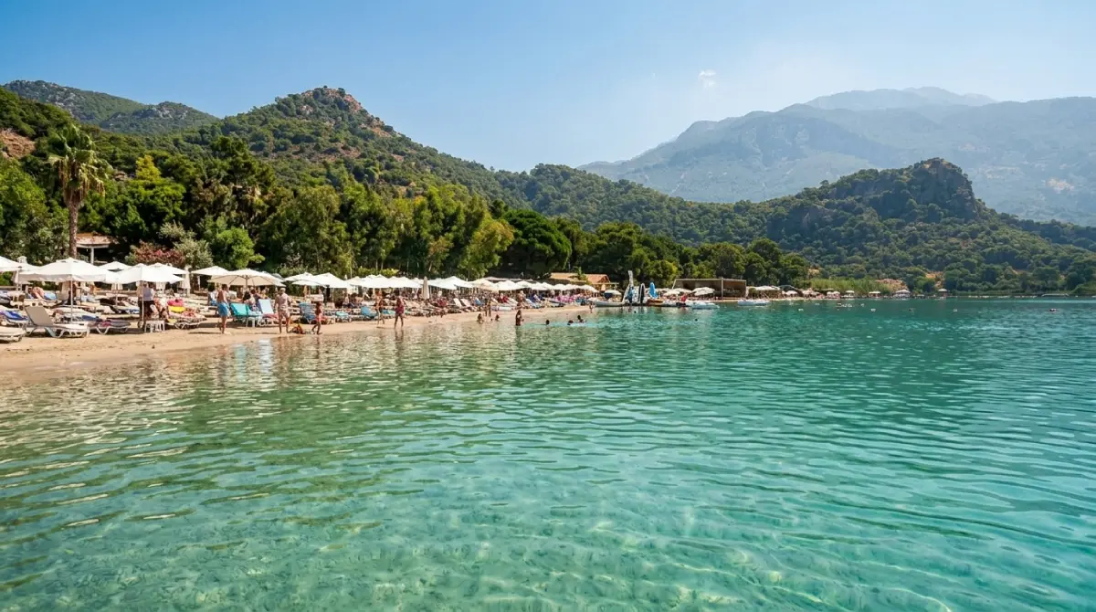
Renowned for jagged shorelines, pine-forested hills, and azure coves. Home to
whitewashed Bodrum, yachting capital Marmaris, and
world-famous Ölüdeniz & Fethiye with the iconic Blue Lagoon. Summers
here are slightly less humid than the southern Riviera.
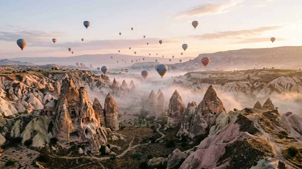
The vast high plateau features capital Ankara, but the crowning jewel
is surreal Cappadocia (Göreme): volcanic tuff fairy chimneys, ancient
rock-hewn underground cities, and magical dawn skies filled with hundreds of hot air
balloons.
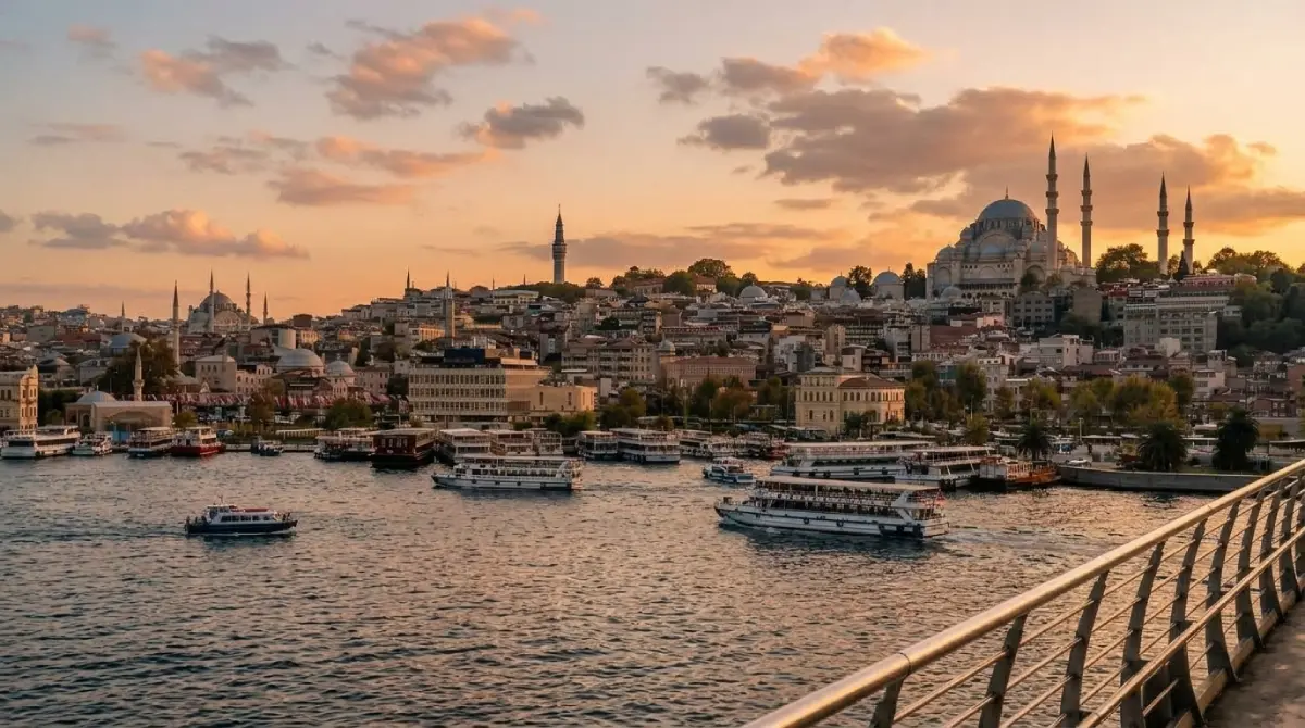
The northwestern corner surrounding the Sea of Marmara. Anchored by legendary
Istanbul—the world's only metropolis straddling two continents across
the Bosphorus Strait—as well as the early Ottoman capital of Bursa.
A humid, emerald-green mountain strip featuring Trabzon and
Rize. A world of alpine pastures, clifftop Greek Orthodox monasteries
(Sumela), and mist-shrouded terraces cultivating famous Turkish tea.
Where is Turkey Located and How Big Is It Compared to Europe?
Turkey (officially the Republic of Türkiye) is a distinctive transcontinental
nation acting as a historic land bridge between Southeastern Europe and Western Asia (the
Middle East). An overwhelming 97% of its territory forms the Anatolian Peninsula in
Asia, while a compact 3% European enclave (East Thrace) directly borders Greece
and Bulgaria.
Geographic Scale: Turkey vs
the UK & Europe
First-time travellers often underestimate the sheer physical scale of the country.
Turkey is a massive geographic titan in the Mediterranean and European sphere:
783,562 km²Total Area of Turkey (302,535 sq mi)
242,495 km²Total Area of the UK (93,628 sq mi)
3.2x LargerScale vs the United Kingdom
7,200 kmCoastline Length (4,470 miles)
Measured straight as an arrow, the distance from Turkey's westernmost border in Thrace to
the eastern frontier with Iran is nearly 1,600 km (1,000 miles), while
spanning 550–600 km from north to south. This enormous footprint encompasses multiple
climate zones simultaneously: while vacationers swim in balmy 25°C sea temperatures in
Alanya in May, deep snowpacks often still crown the peaks of Eastern Anatolia around Mount
Ararat (5,137 m / 16,854 ft).
Who Does Turkey Border? The 8 Neighbouring Countries
Occupying a strategic crossroads of civilizations, Turkey shares over 2,648 km (1,645 miles)
of land boundaries with eight sovereign states:
European Borders (Northwest)
Greece: 206 km border, running primarily along the Evros
(Meriç) River.
Bulgaria: 240 km frontier cutting through the forested
Strandzha mountains toward the Black Sea.
Caucasus Borders (Northeast)
Georgia: 252 km boundary (anchored by the bustling Sarp border
crossing near Batumi).
Armenia: 268 km border (physically closed since the 1990s due
to regional diplomacy).
Azerbaijan (Nakhchivan): Turkey's shortest land border—just 9
km along the Aras River.
Eastern Border
Iran: 499 km of rugged mountain border, largely established by
the historic Treaty of Zuhab back in 1639.
Southern Middle Eastern Borders
Iraq: 352 km of dramatic, high-altitude alpine terrain in
southeastern Anatolia.
Syria: Turkey's longest land frontier, extending for 822 km.
The 4 Surrounding Seas & Strategic Straits
Very few countries on Earth command access to four distinct marine environments. These
waters shape Turkey's maritime identity and holiday appeal:
Mediterranean Sea (Akdeniz): Washing the southern shore, this is the
heart of the Turkish Riviera. It features the warmest, saltiest waters and basks in more
than 300 days of sunshine each year.
Aegean Sea (Ege Denizi): The western coastline, noted for crystal-clear
turquoise waters, thousands of rocky pine-covered coves, and pleasant summer meltemi
breezes.
Black Sea (Karadeniz): The northern border, characterized by cooler,
humid weather, lush tea and hazelnut plantations, and dramatic coastal cliffs.
Sea of Marmara (Marmara Denizi): Turkey's internal sea spanning over
11,000 km². It connects to the Black Sea via the Bosphorus Strait in
Istanbul, and to the Aegean via the Dardanelles Strait. Under the 1936
Montreux Convention, Turkey exercises sovereign authority over all naval and commercial
maritime transit passing between the Black Sea and the Mediterranean.
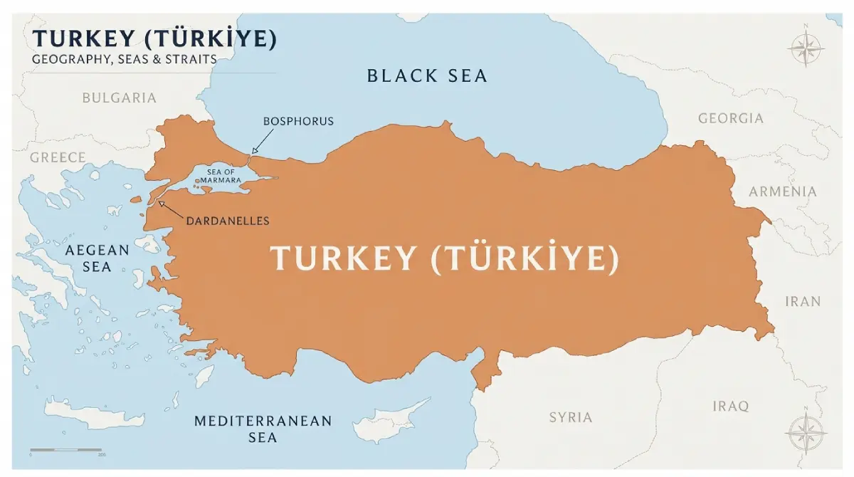
Seas and maritime waterways of Turkey: The Black Sea, Marmara, Aegean, and
Mediterranean interconnected by the vital Bosphorus and Dardanelles straits (source:
tucoo.pl)
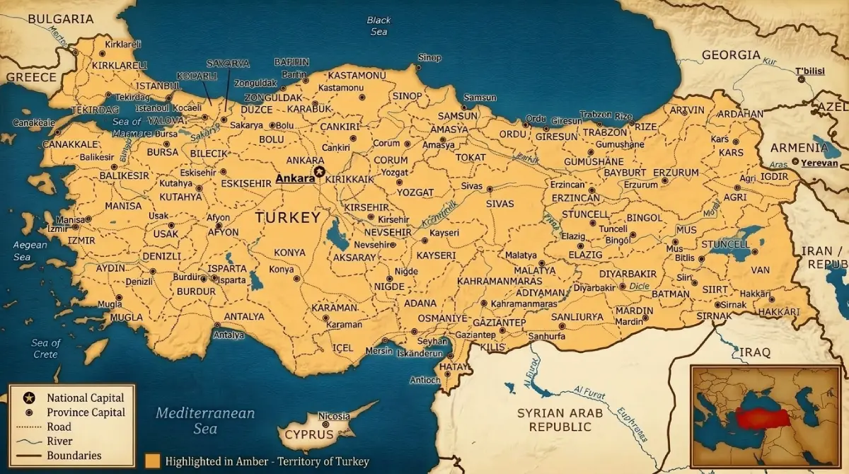
Administrative Provinces: 81 Iller & Car License Plate Codes
Turkey is organized into 81 administrative provinces (iller), each overseen
by a provincial governor (vali). Provinces are usually named after their capital city (e.g.,
Antalya Province, Izmir Province).
Insider tip for holidaymakers: Each province is assigned an official
administrative number (from 01 to 81, historically arranged in alphabetical order). These
numbers form the first two digits on all Turkish vehicle registration
plates. While riding in a taxi or renting a car, you can instantly tell where a
vehicle originates:
01 – Adana
06 – Ankara (the national capital)
07 – Antalya (every taxi, bus, and transfer van on the Riviera)
34 – Istanbul (the largest vehicle fleet in the country)
35 – Izmir
48 – Muğla (covering Bodrum, Marmaris, and Fethiye)
Distances Between Major Cities & Holiday Resorts in Turkey
Given the vast geographic scale of the country, comparing drive times against domestic flight
options is sensible. Domestic flights (Turkish Airlines, Pegasus, AJet) are frequent, reliable, and
very affordable.
Route
Road Distance
Driving / Bus Time
Direct Domestic Flight
Istanbul – Antalya
approx. 700 km (435 miles)
8 – 9 hours
1 hr 15 min
Istanbul – Ankara
approx. 450 km (280 miles via O-4)
4.5 – 5 hours (or High-Speed Train YHT: 4 hrs)
1 hour
Antalya – Alanya
approx. 135 km (84 miles via D400)
2 hours
None (road transfer)
Antalya – Cappadocia (Göreme)
approx. 500 km (310 miles)
6.5 – 7.5 hours
Connecting via IST
Antalya – Pamukkale (Denizli)
approx. 240 km (150 miles)
3.5 hours
None (coach / driving tours)
Izmir – Bodrum
approx. 240 km (150 miles)
3 hours
None (direct coaches)
Bodrum – Marmaris
approx. 160 km (100 miles)
2.5 hours (or seasonal passenger ferry: 1 hr)
None
Island Neighbour
Cyprus – Turkey's Close Mediterranean Neighbour on the Map
Glancing across the eastern Mediterranean basin on a regional map, one cannot overlook
Cyprus—the third-largest island in the sea, positioned merely 65–70 km (40
miles) south of Turkey's Mersin province and the eastern Turkish Riviera.
During the summer season, regular passenger ferries and hydrofoils link Turkish mainland
ports such as Taşucu and Alanya with the picturesque northern harbour of Kyrenia (Girne).
Travellers should note the unique geopolitical situation: the northern portion functions as
the Turkish Republic of Northern Cyprus (declared in 1983 and recognized
internationally solely by Turkey). To learn more about island logistics, historic ruins, and
holiday beaches, browse our specialized guide: Cyprus Travel Guide tucoo.pl.
REKLAMA
Common Inquiries
Turkey Map & Geography – FAQs
Where is Turkey located and which continents does it span?
Turkey sits on the boundary between Southeastern Europe and Western Asia. 97% of its
territory is the Asian Anatolian Peninsula, while 3% forms European East Thrace. The two
landmasses are separated by the Bosphorus Strait, the Sea of Marmara, and the
Dardanelles Strait.
How many countries share a land border with Turkey?
Turkey borders eight sovereign nations on land: Greece and Bulgaria in
Europe; Georgia, Armenia, and Azerbaijan (Nakhchivan) in the Caucasus; and Iran, Iraq,
and Syria in the Middle East. The total land boundary measures over 2,648 km.
How big is Turkey compared to European nations?
With an area of 783,562 km² (302,535 sq mi), Turkey is more than
3.2 times larger than the United Kingdom (242,495 km²) and larger than
France and Germany combined. Its coastline extends over 7,200 km across four seas.
Which seas surround Turkey?
The country is bordered by four seas: the Mediterranean Sea to the
south, the Aegean Sea to the west, the Black Sea to
the north, and the inland Sea of Marmara connecting the Black and
Aegean seas.
What is the capital city of Turkey?
The official capital since 1923 is Ankara, situated in the heart of
central Anatolia. However, historic Istanbul remains the country's
economic engine, cultural powerhouse, and largest metropolis with over 15 million
residents.
I am an avid enthusiast of travel, tourism, and web development. I craft every guide with dedication and attention to detail based on personal travel experiences, enhancing selected visual materials and editorial content with modern digital tools and AI graphics. I make every effort to ensure all information, prices, and tips remain accurate and up to date. If you notice an error, inaccuracy, or recent changes on the ground – I would be grateful for your feedback:
 GEOGRAPHY & ITINERARY